We made it back into town just over two weeks ago. The field season went well, despite a few challenges from sea ice, snow drifts on the beach and general cold weather. There was a huge amount of catching up to do (nearly 4000 emails), three projects which needed various forms filed, an MOA which had to be done for this project, some radiocarbon calibrations to write up for another project, lots of equipment which needed to be cleaned, dried, put away or returned, and many artifacts and samples which needed processing. Although I had lots of help, I’ve been working 16 hour days since before we went into the field, and something had to give.
Unfortunately, we didn’t have good connectivity in the field, so the only updates I could send were from my deLorme InReach. At 160 characters per message, it really isn’t up to blog posts. That means I’m sort of going to have to do some catch-up posts. I head to Deering for a monitoring project on Saturday, and it’s not clear how good the connectivity will be there either, so there may be another gap.
I have been really busy the last month, trying to finish several reports and papers, plan for the summer, and get ready for a research visit from Tony Krus of SUERC, who was a member of the 2008 Nuvuk field crew before he headed off to grad school. He is now Dr. Krus, and was able to get a grant to come over and work on Bayesian modeling for Barrow area dates, as well as attempting to improve the value for DeltaR (a correction factor used with radiocarbon dates on marine organisms to compensate for the excess older carbon found in the oceans). Between the massive amount of writing I was doing and smashing a finger getting luggage out of the overhead coming back from a trip, I’ve not been blogging.
I hope to catch up with things a bit; there’s been considerable activity on the DONOP/global change threats to cultural and natural heritage front, as well as planning for Walakpa.
I am writing this from Disney World, where I have gone to talk about archaeology, particularly global change threats to the archaeological and paleoecological records. The Society for American Archaeology is having its 81st Annual Meeting here, so I am sitting on the 11th floor of a hotel with a view across a lot of fairly low lying land. It might be high enough to survive several meters of sea level rise, but by 20m, the Orlando airport looks like it gets iffy.
I organized a session on, surprise, global change threats to the archaeological and paleoecological records. It should be good, with people presenting on various aspects of the problem in various part of the world (mostly the North), and some possible solutions being tried as well. The session is Saturday morning, and we’ve got Ben Fitzhugh from UW as discussant, as well as a 15 minute discussion slot. I hope we get good attendance, because this is a critical issue for the future of the discipline (and maybe of people in general). Of course, in their infinite wisdom, the schedulers put us directly opposite the session in honor of Lou Giddings, which deals with coastal Alaska. I actually have to read a paper for someone because the primary author couldn’t travel and the second author is giving a paper in the Giddings session at the same time! Meanwhile, I’d already gone to most of the papers I want to see today by 10:30 AM.
Last night I went to the President’s Forum, which was on Climate Change and Archaeology. Dan Sandweiss had organized a nice set of speakers. One of them was Paul Mayewski,who specializes in ice cores and their analysis. He talked about some new software they have, and then he described a new instrument they have which can sample cores in tiny increments, so they can actually see individual storms thousands of years ago in the right type of core! I introduced myself afterwards, and asked if it might work on ice wedges, following up on a suggestion Vlad Romanovsky had made during ASSW. He thought so, and offered to pay to ship a trial wedge sample to his lab so they could try it. Now I just have to get a good sample. Hopefully it works, but either way it will be interesting.
I’ve got a meeting later today (and another on Saturday for those who can’t make today’s) for folks who want to help with 2016 Walakpa Archaeological Salvage (WASP 2016). Today we meet at 5PM at registration, and anyone who is interested is free to come along. Now I have to run off and find the meeting of the newest SAA committee, Climate Change Strategies and Archaeological Resources (CCSAR).
Folks who have been reading this blog are aware that erosion of archaeological sites due to global change effects (warming, sea level rise, etc.) is a huge problem where I live and work. Rapid decay of the exquisitely preserved organic contents of the sites is also a huge problem. But a blog only reaches so many people and actually dealing with the sites and otherwise doing my day job means that I can’t spend endless time on outreach. So when a member of the media is interested, I take the time to talk to them. Sometimes something comes of it, other times not.
Last summer Eli Kintisch, who writes for a number of scientific publications came up and spent a few days in Barrow. He managed to spend a day at Walakpa, although his schedule meant he couldn’t be there for the whole thing. He’s been working on it since, and I think the result is pretty engaging. The resulting article was just published by Hakai Magazine here and simultaneously by the Smithsonian website here. Hakai focuses on coastal issues and just recently published an article on Tom Dawson and SCAPE’s work in Scotland dealing with similar problems (minus the permafrost thawing and sea ice retreat).
It’s a big problem, and one that will take a considerable input of human and financial resources to deal with. We’ve only got a few decades (less in many cases) before all the cultural heritage and paleoenvironmental information in these sites is gone for good.
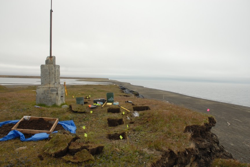
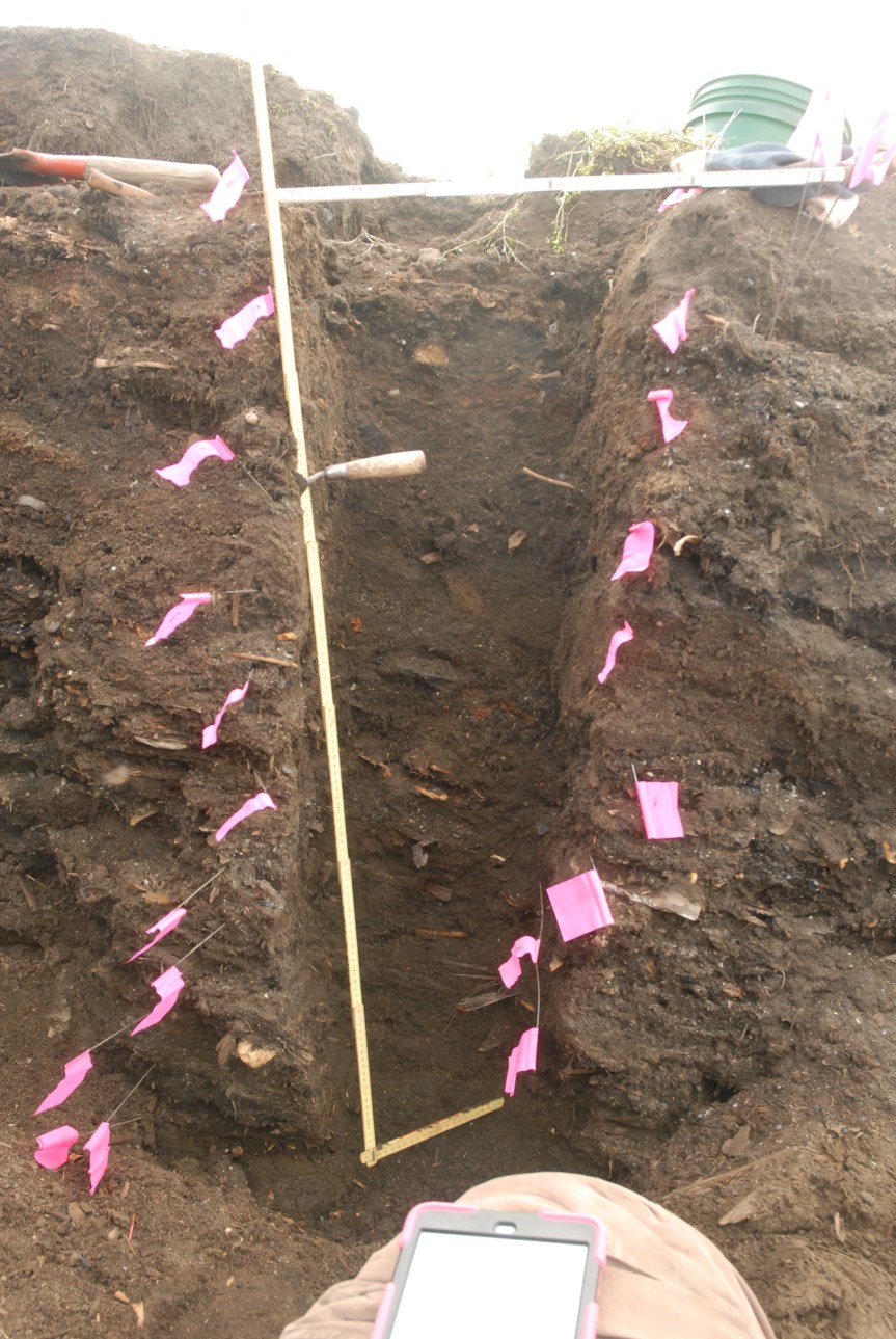
Tests in a midden at Walakpa. A new date shows it is Late Western Thule, between 300-500 years old.Column sample at Walakpa, Summer 2015.
I spent most of the week in Seattle at the Arctic Observing Open Science meeting. Ben Fitzhugh and I were the point persons for the broader GHEA/IHOPE Emerging Knowledge Hub on Global Environmental Change Threats to Heritage and Long Term Observing Networks of the Past. This is a long and fancy way of talking about the threats that sea level rise, ice retreat, and permafrost warming pose for archaeological sites in the North. Since this was not an archaeological meeting, most of the folks were either natural scientists or resource managers. We focused on the kind of data that archaeological sites contain that are more than relevant to answering the kinds of questions they are asking, while pointing out that the data is vanishing quickly. The library is on fire!
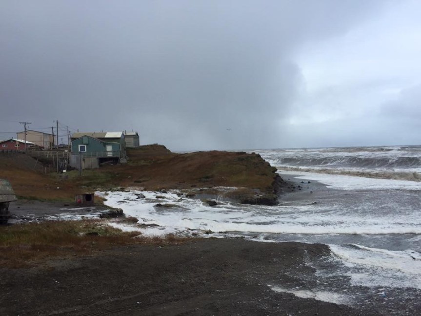
Waves eat at the Utqiaġvik bluffs.
Ben and I each were the lead on a talk (both massively multi-authored), and we also did a poster, with a similarly large number of contributors. Ben’s talk was in the Marine Ecosystems session. It seemed like it interested the audience, which was primarily oceanographers, and related agency and funding folks.
Mine was in the Human Dimensions session, since the Coastal Processes session we had aimed for apparently didn’t get enough papers. I followed a paper on frozen heritage (primarily ice patches and the preliminary stages of development of site evaluation schema) by Martin Callanan and Shelby Anderson, so the issues were thoroughly driven home. The audience included a number of natural scientists (!), and the discussions included the relevance of archaeology to both other fields of research and to developing toolkits for sustainability.
Our hope is we woke some of our colleagues up to both the potential of archaeological sites to provide data, and the need to find a way to get that data that doesn’t rely entirely on Arctic Social Science funding.
My talk and the poster are up on both my Academia.edu and ResearchGate pages, if you would like to see them.
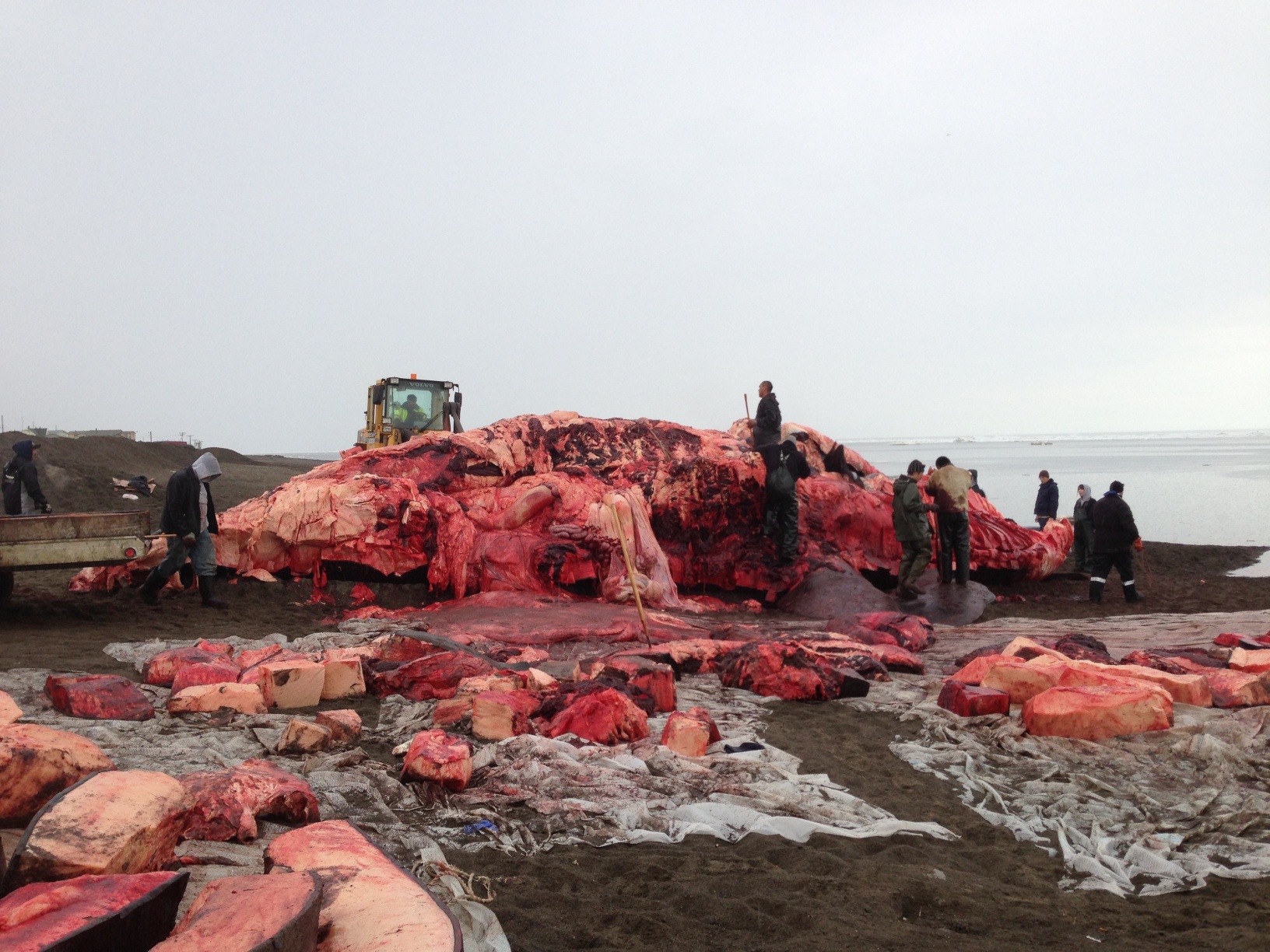
Yesterday and today were great days for Barrow. Last night, showing real persistence in the face of very discouraging conditions this spring, a number of crews went out. Anagi crew took a 54 footer, the first whale taken in Barrow this spring (or summer, as some of my Facebook friends pointed out). The whale reached the beach just after midnight, according to Coby, who took a picture of the landing at 12:05 AM.
I had gone to bed early, trying to make up for sleep lost due to something or other wrong with my shoulder, and slept right through it. None of my co-workers did. I got a call at 7AM from Trina, who had been helping all night and had realized she couldn’t stay awake for work (or give rides to the others). I headed for town. I stopped at the whale first. As you can see, the weather wasn’t great, as it often isn’t in the morning in summer, and it actually started raining pretty hard while I was there.
Approaching Anagi crew’s whale.About 9 hours into the butchering.Shares of maktak waiting to be put away.
A bowhead whale weighs roughly a ton a foot, so cutting up a whale this big involves a tremendous amount of labor. People had been working for about nine hours at this point, and still had a way to go. The maktak (skin & blubber–very tasty indeed) was mostly off. There was a bit waiting to be taken either to the captain’s cellar to be put away or divided as shares, but a lot of it had clearly already been taken care of and put away.
I thought a panorama of the scene might be interesting, so–thanks iPhone.
Panorama of Anagi whale being cut up on beach in Browerville, June 27, 2013.
After that, I got Coby, who had apparently only been at the whale until 2:30 AM, & we tried to find RJ, with no luck. Went back to the BARC to discover a message from my assistant Tammy, who had been at the whale until 4AM, saying she would be late. Since she is Michael’s ride, he wasn’t there either. Coby & RJ started working, and I started trying some VZAP troubleshooting, which required running a logger while trying to access the site and then forwarding the logs to the VZAP team at ISU. I hope it helps, and we don’t discover the problem is just awful connectivity. Jan, the middle school teacher who is volunteering, wasn’t in, but she rides her ATV to the lab, so we figured she had decided the rain was a bit much. After I finished with the logging on the computers, I fired up my email, to discover one from Jan saying she had apparently slept right through her alarm, because she’d been at the whale until after 2 AM! Coby and RJ decided to call it a day around noon, to go back to the whale.
All this made for limited progress in the morning. A good bit of the afternoon was taken up with things connected with various non-archaeology projects I manage.
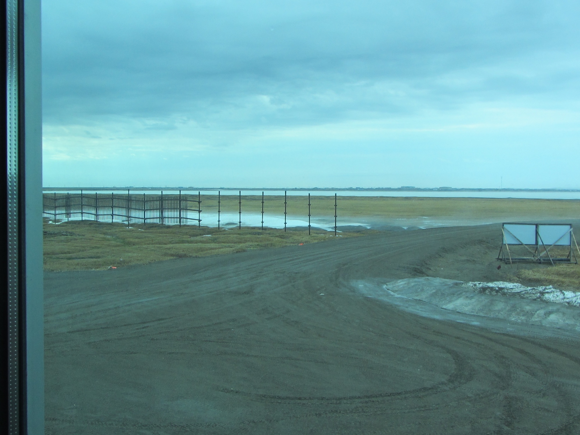
The weather warmed up a good bit later, and the south wind was actually ablating the snow in the drifts by the snow fences, making fog billow off them. It was pretty spooky looking.
Fog coming off the snow banks.
ADDED 7/1/2013: If you don’t think people should hunt whales, well, it’s a free country and you are entitled to your opinion. But before you try to post a rude comment, please check here and here.
And it’s been great so far! The weather has been gorgeous, not too cold or windy. The light this morning was amazing, golden reflecting off the clouds & snow. Unfortunately no pictures from when it was best because I was trying to get stuff done before I start a series of back-to-back trips, although I did look out the window a lot when I was making phone calls. I did get some a bit later, and it is still pretty great.
View out my office windowLooking south around 3 PM (local noon).Clouds over Barrow & the Chukchi
Last year I got to finish unwrapping the child on my birthday. This year was not nearly as exciting, but then archaeology really isn’t like Indiana Jones… much. I finished and sent the quarterly report to the client on our activities supporting the ARM site. It is good to look back and see what has been done, and I’m using a format that asks for lessons learned, so it forces one to think and track, which is not a bad thing and easy to skip when things get busy.
I made the final corrections on the encyclopedia entry on frozen sites, and am just waiting for one image to upload it to the publisher. The Point Hope chapter is being read (quickly, I hope) by a couple of friends, and then will get sent to the editors for review. I still need to recalibrate C14 dates for Northern Archaic and Palearctic, but that can get added to the final.
One of the things I’m involved in as part of the GHEA/Long-Term Sustainability RCN is a workshop on the Kurils & Aleutian Islands. I’m a participant, not a discussant, which is a bit odd since I’ve never stepped foot in either one of them, or even worked on a collection from either area. The workshop involves putting up some articles and a conference paper ahead of time, and some on-line discussion, in hopes that we will all be up to speed by the time we get to Seattle, and can hit the ground running. I got put in a group looking at Ecological Dynamics and Paleoecological Histories, which is very cool. I definitely have some catching up in the literature to do here, so I spent a chunk of the afternoon downloading the various papers & such folks in my group (and others) had put up. I have put them into my Dropbox and synced my iPad, so I can read them while traveling. It turns out I am not the only one who doesn’t have a conference paper done, and some of those that are there are not that formal :-).
I also need to find a way to get a paper I wrote on bearded seals in Greenland up. I don’t have an electronic copy, but it seems pertinent. One topic that seems to be coming up is possible sea ice extension into the region and folks seem to be making a few unwarranted assumptions about how species that are not now present in the area behave. That would of course skew any climatic interpretations one might be trying to derive from faunal data. I think the bearded seal paper covers that and provides a good example of some issues that are counter-intuitive.
And Barrow caught their final whale of the 2012 season! Hey hey hey Anagi Crew!
View leaving the office.
Shortly after I got home there was a know at the door & flowers & balloons arrived! That was quite the surprise, since Glenn had already bought me a huge arrangement of flowers (and a Kindle Paperwhite, which is supposedly in transit). I unwrapped them, and they turned out to be from the entire staff at UICS (arranged in secret by Tammy). The flower arrangement is gargantuan!
Flowers & Balloons, with me for scale.The flowers in close-up.
On Friday afternoon we headed to Point Barrow. I’d gotten KTUU set up with Aarigaa Tours, who picked them up in town at Top of the World Hotel, and then picked me up at my house at NARL on the way out to the point. I’d run home from work to change into my warm gear. A good thing, too, as will become clear later.
We’d been having a pretty strong blow from the NNW, and waves had actually been coming up onto the road. The road to the point had actually been closed right by Piġniq (Birnirk), because the waves had been breaking over the road and had done some significant damage. We were in a van equipped for off-road travel, so we were OK, but we had to detour through the cabin area. Once past there, the road was still in pretty good shape, but we could see water seeping in under the gravel berm. Once we got out a bit farther we could see a number of vessels & barges that had come into Elson Lagoon to anchor up and wait out the rough weather.
Barges in Elson Lagoon, seen from the trail by the marked graves.
Once we got to Nuvuk and got a look at the site, it was a bit depressing. However, it made a perfect example of coastal erosion in action, and made it really easy to illustrate how information about the past, which could have application to understanding what directions to take to have a sustainable future, is being lost. At least 10 feet (3 m) of the site had been lost to the ocean since couple weeks ago. The gravel slump that had been protecting the face was gone, and thawing permafrost was sticking out and undercut.
Exposed thawing Ipiutak level at Nuvuk.
And in that permafrost was the same strandline debris that has proven to be a marker for the Ipiutak occupation. There was a large patch of what looked like fur or peat (which often seems to be found on the floors of Ipiutak structures) and an area where the wood seemed to be far more aligned and level than is normal for a strandline, but would be quite typical for an Ipiutak floor. I tried to get decent pictures, but in the end decided I needed to try to get a sample. I tried walking down on the permafrost, but it was angled, and I couldn’t get close enough without falling off. There were big waves, and the bluff was undercut. If a really big one came at the wrong time, it could wash me off my feet.
Finally, I asked Ricky Bodfish, who was driving the tour van & giving the tour except for the archaeology part, if they had a rope. He did, so he dangled it down the bluff by me, we waited until right after big waves when it looked like a lull and I went down to check it out and try to get close-ups and a sample.
Sampled peat in Ipiutak layer. My finger for scale.
The patch of material turned out to be peat, which I was able to sample, and will send out for dating. My camera got some spray on it, but there was not way or time to clean the lens, so I just kept shooting. Unfortunately a pretty big wave came and dumped gravel on the surfaces just before I got a shot off of the wood, (I managed to turn so I caught it on the side where KTUU’s microphone pack wasn’t) and I could hear the next one was even louder. I ran, and made it into an area above the waves before the big one broke.
Edge of eroding Ipiutak layer showing some of the aligned wood. The white is the foam on the wave that is going under this layer into the bluff.
Fortunately, nothing soaked through the Carhartts so I just took them off for the rest of the trip.
We had been monitoring the tower we’d put out in June, and just a few days earlier had thought it would be fine. However, the storm had taken out a lot of the bluff, and I wound up calling & texting the guys who work on the ARM project for UICS. They wound up going out later that evening and hauling the whole thing about 50 feet (15m) farther back from the edge. Just in time, since by the time they got out there, they figured it was 2-3 feet (< 1m) from the edge.
Getting close to the edge.
After that, the KTUU fellow wanted to see the farthest North point and go to the bone pile to see if there were any bears. We set off, and almost immediately had to detour. The trail we normally use to get to the site, which is always dry, had water all over it from the storm surge.
Trail covered by storm surge.
We made it to the farthest North point, which was a bit less far North than previously. The storm surge had made it to the tip of one of the whale jawbones, and about 10 feet was missing here too. However, we did get some nice light, and the KTUU guys got busy.
Crew and van near Farthest North PointDan Carpenter gets ready to shoot at the Farthest North Point.
KTUU crew at Farthest North Point.
Unfortunately, the trip to the bone pile did not come off. The storm surge had caused it to nearly become an island. Ricky was not sure how solid the ground was, and we did not want to get stuck there, so we gave it a miss. On the way back to the road, it was really clear how much of the Chukchi side of the Point Barrow spit had been eaten. The ocean was almost up to the berm along the road, and there used to be a fairly wide strip of gravel there.
I haven’t been posting much lately. Not that I haven’t been writing a lot, but it’s all been papers, reviews, more papers, quarterly reports, monthly reports, bi-monthly reports and so forth. I’ve still got a couple of papers to finish, not to mention homework for an on-line course I’m taking, and of course, that wonderful April ritual of taxes. Then there are a paper and a presentation for the SAAs in Memphis.
The most fun things to write are letters of recommendation for students who have worked on the Nuvuk Project. It is really great to see kids graduating and moving on to college, although we do miss them when they move on. I’ve been working on ways to continue the archaeology program after the Nuvuk grants are done.
The sun is up for about 15 hours a day now, and will be up full-time in just over a month. This is a pretty time of year, and I’ve gotten some nice pictures. Here’s one of the conjunction of Venus, the moon and Jupiter.
A couple of days ago, I looked out the window, and noticed frost flowers hanging on the clothesline, swaying in the breeze! I’ve never seen anything like it.